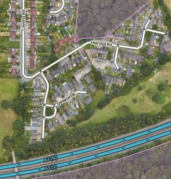
Glebelands
| H I N C H L E Y W O O D | ||||||||
| E | 
|

|

|

|

|

|
C | |
| S | 
|

|

|

|

|

|
H | |
| H | 
|

|

|

|

|

|
E | |
| E | 
|

|

|

|

|

|
S | |
| R | 
|

|

|

|

|

|
S | |

|

|

|

|

|

|
N | ||
| O X S H O T T | ||||||||
2024 Planning Applications
№ 9
ADDRESS: 9 Glebelands
|
Historical Notes
The Glebe
Holy Trinity was not endowed with a glebe in its own right. (In ecclesiastical law, glebe is land devoted to the maintenance or benefit of the incumbent, with the freehold held by the incumbent.) In earlier times, virtually every church of common right had to have a house and glebe of at least 10 acres, collectively known as the manse, before the church could be consecrated. However, the situation changed around the time Holy Trinity was built, with the enactment of Ecclesiastical Leasing Acts of 1842 and 1858, the Tithe Act of 1842, the Glebe Lands Act of 1888 and various other acts.
The only glebe in Claygate was located either side of the far end of Coverts Road. The freehold, or copyhold as it was then called, of that part lying on the east side of the road was in the possession of the Rev Wilfred Speer in 1843 and the Rev Bernard Bosanquet in 1910, both of St. Nicholas, Thames Ditton. On this land, which changed hands many times after it was sold by Bosanquet in 1910, stood a house known as Glebelands which was demolished before the Glebelands estate was built. Apart from the houses that now border Coverts Road, that part of the glebe which lies on the west side of the road has remained farmland.
PLUTO
In the latter stages of the Second World War a government-owned pipeline ran due east and west virtually across the centre of the glebe of Claygate. This was part of the PLUTO system—Pipe Line Under The Ocean—for the supply of fuel across the English Channel to the allied forces during the invasion of Normandy.
The route Pluto takes from the pumping station at Walton-on-Thames towards the Isle of Grain near Chatham and Dungeness—i.e. Dumbo in Kent—passes through Epsom.
Leaving the pumping station the route goes towards Esher passing south of Claygate where it passes under the A3.
It continues towards Chessington crossing the A243 around the area between the Garden Centre and the World of Adventure.
Having crossed the road, the line enters the Borough running alongside the B280 south of the Hospital Cluster Site, where a marker post can be seen.
Continuing over Epsom Common it passes north of the Wells Estate and crossing the A24 heads towards Woodcote and the Royal Automobile Club. It enters the Club grounds having crossed Wilmerhatch Lane near The Lodge, where another marker post can be found.
Travelling up Captains Drive it leaves crossing Langley Vale and heads over Epsom Downs where it passes under part of the Derby Course before crossing the 'switchback road' and heading towards Tadworth.
It passes north of Tadworth before leaving the Borough when crossing the A 217 near Shelvers Way before heading towards Kingswood where another marker post can be found.
References
- Peebles, Malcolm (1983). The Claygate Book. (Millennium edition). Stockbridge: by BAS Printers Ltd. ISBN 0-9508978-0-9.

- Many thanks also for the photos, many supplied by Terry Gale, from the Claygate Local History Facebook group.
- Wikipedia

